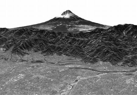
On February 15, the Japan Aerospace Exploration Agency (JAXA) exhibited the first photographic images captured by the Daichi advanced land observing satellite launched in January. Daichi is equipped with the three types of sensors, including the world?s first Panchromatic Remote-sensing Instrument of Stereo Mapping (PRISM), which simultaneously captures images from three directions to create 3D images of the Earth's surface.
The PRISM images, taken on the morning of the February 14, show the area around Mt. Fuji and Shimizu Port in Shizuoka Prefecture. Objects as small as 2.5 meters (8.2 feet) across are visible.
Daichi?s 3D images of the area around Mt. Fuji show Kofu City?s urban sprawl, the Fuji Five Lakes (Fujigoko), and the detailed terrain of the snow-capped peak of Mt. Fuji. Small buildings and roads are visible in the images, which were taken from an altitude of 700 kilometers (435 miles).
Daichi uses PRISM to create maps on the scale of 1:25,000. The satellite is expected to play a key role in disaster relief by quickly gathering image data of areas hit by large-scale disasters.
[Source: Mainichi Shimbun via Yahoo! News Japan]
UPDATE: Check out the 3D video compiled from the images (MPEG: 3.6M)

No Comments